Posts

Showing posts from January, 2022

T-Bone Trail

Image
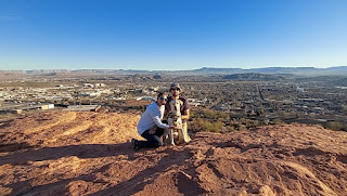
Monday, January 24, 2022  Hike #10 of 2022.  4.5 miles / 39.0 miles YTD Today's hike was right on the very edge of town on the T-Bone trail.  There is a parking area at each end of this trail so you can approach it from either direction.  We have done a small portion of the trail - starting from the end closest to the city - a couple of times.  Once was on a vacation out here a number of years ago and the second was not long after we moved here.  Both of those times, we turned off the T-Bone trail and continued on down a different trail.  This time, we parked at the end that is farther outside of town and hiked in from the opposite direction.  For the most part, this is just another OHV trail.  So I honestly was expecting it to be rather boring.  It is fairly straight and it goes through a wide open area so the majority of the views are far off in the distance, until you reach Pioneer Park on the edge of the city.  However, even tho...

"Summit" Arch

Image
Sunday , January 23, 2022  Hike #9 of 2022.  2.5 miles / 34.5 miles YTD The destination of today's hike was to try to get to an arch that we had seen across the way on our hike last Sunday.  As we were taking in the views from the overlook of that hike, I pointed out to Dan an arch that I could see on the other side of the canyon, not all that far down from the edge.  I was actually wondering if it might be a bridge because it was wide and appeared to be rather flat.  However, we now know (thanks to Google) that the difference between an arch and a bridge is not the shape but how they are made.  Bridges are made with water (makes sense) and arches are made with other weathering effects, such as wind.  I highly doubt this could have been made with water, considering where it is, so we will assume it is an arch. Where we were last week when I noticed the arch.  It is not in this photo but it is on the canyon wall on the right side. To try to get to ...

Summit's 2nd Birthday - Chuckwalla

Image
Thursday , January 20, 2022  Hike #8 of 2022.  3.0 miles / 32.0 miles YTD We don't generally do weekday hikes but today is Summit's 2nd birthday so we had to take her on a hike to celebrate since it is her favorite thing to do (and ours)!  We have all been to this area before but it is right on the edge of town so it is quick and easy to get to.  And we didn't have a ton of time because Dan had to work so we needed to be home in time to have dinner before he had to leave.  But we got in a solid 3 miles of adventure!   It was another nice day so the trail was actually quite busy (probably other people also trying to fit something in after work but before dinner/dark).  So we ended up abandoning the trail after about 1.2 miles and decided to just wander around the rock formations instead.  But Summit loves jumping/climbing so it fit her style well and it was actually more fun than just walking down the trail. I brought along a "Birthday Girl" h...

Cathedral Arch

Image
Monday, January 17, 2022  Hike #7 of 2022.  4.0 miles / 29.0 miles YTD The plan for today had been another combination off-road adventure with the Tacoma paired with a hike.  This one was just a little farther away than we normally travel for our hikes, since there are so many options close by, but I would still consider it close to home, in general.  Today we went to see the Cathedral Arch in the Beaver Dam Wash National Conservation Area.  The road to this trail was another long gravel road off the main highway.  A high clearance vehicle probably wasn't really necessary until the trailhead but it is so nice to have the comfort of knowing our vehicle is pretty much going to get us anywhere we want to hike.   We parked at the trail head and started on an OHV trail - but this one was much more of an ATV type OHV trail, than a truck trail.  We weren't really paying very close attention to AllTrails and missed the first turn off onto another bra...

OHV Trail

Image
Sunday, January 16, 2022  Hike #6 of 2022.  3.0 miles / 25.0 miles YTD Today was a combination of an off-road adventure in the Tacoma paired with a short hike.  We took the OHV trail up into Red Cliffs and past the Yant Flat/Candy Cliffs trailhead.  Shortly past that, we took an "very off-road" trail off the "mostly off-road" trail and then parked so that we could hike the rest of the way to the overlook.  There are actually two branches that you can take to two different points of the overlook so we did the one to the left first and then went back to the truck and did the one to the right. Heading back toward the truck after taking the branch to the left. The branch to the left didn't really have much opportunity for exploring, other than to enjoy the view at the overlook.  However, once we got to the end of the vehicle path on the branch to the right, we were able to continue on down a foot trail that opened to a wide sandstone area that led to a gorgeous...

Bracken's Loop

Image
Saturday, January 15, 2022 Hike #5 of 2022.  8.5 miles / 22.0 miles YTD Today is the 22nd anniversary of the day that Dan asked me on our first date so, of course, we would celebrate by going hiking!  We did the 8.5 mile Bracken's Loop, and it was a tough one!  It starts out on a hard packed sand road, that turns into a normal sand road until you take the turn-off onto the trail, and then it becomes deep sand for the entire trail, with some sections of decent elevation gain.  Summit loves sand and and her natural four wheel drive makes her really good at getting through it - much better than we are! Summit engagine her natural four wheel drive. When we pulled into the "trailhead" (which is a long parking area along a main road), it was full of cars and horse trailers.  So much so that we second guessed going for a little bit.  The first part of the trail (the hard packed sand portion) was actually quite busy - with hikers, mountain bikers and horse riders....

Cinder Cone

Image
Monday, January 10, 2022 Hike #4 of 2022.  1.0 miles / 13.5 miles YTD Today was just another short hike.  Dan and I had already done this one but wanted to take Summit on it.  There are a few ancient volcanos in the area.  The Cinder Cone Trail is one that is right next to the highway, near the entrance to Snow Canyon State Park.  While this one is short (one mile round trip), it certainly isn't easy.  The trail takes you along the ground to the back side of the volcano before gradually starting up the back and then getting fairly steep up the side (500 feet of elevation gain from the ground to the rim).  The trail goes around the rim of the volcano and you can hike down inside if you wish, but it does not go very far down.  Dan and I did go down inside the last time but did not do that this time with Summit.   The lower side of the rim, at the top of the trail that goes down inside. The 360* views of Snow Canyon, the Pine Valley mountai...

Pink Coral Sand Dunes

Image
Saturday, January 8, 2022 Hike #3 of 2022.  2.0 miles / 12.5 miles YTD Today we went to Pink Coral Sand Dunes State Park and it was incredible!  This adventure might not technically be considered a hike because there was no trail - it was just walking/wandering around.  But it was at a state park so we will consider it so.  The dunes were so much taller and bigger than we were expecting.  The temp was 61*F in the valley, when we left home, but that altitude thing got us again and it was only 49*F, and breezy, at the dunes.  Some of the sand was even covered in snow.  So we were under-dressed in shorts and tshirts and we thought it might make for a short trip.  But once we got out on the dunes, it was actually a bit warmer, and maybe just slightly less windy, than it had been in the parking lot.  The dunes were actually a lot of work to climb up so we warmed up quickly.   Dan and Summit running up the side of the dune. We went up wha...